Ensuring Robustness in Urban Analytics (Urban Street Width Calculator Tool)
To generate actionable urban intelligence, a tool must respect the non-rectangular, often "noisy" reality of our cities. Here is how the Urban Street Width Calculator ensures high-precision results even in complex urban fabrics.
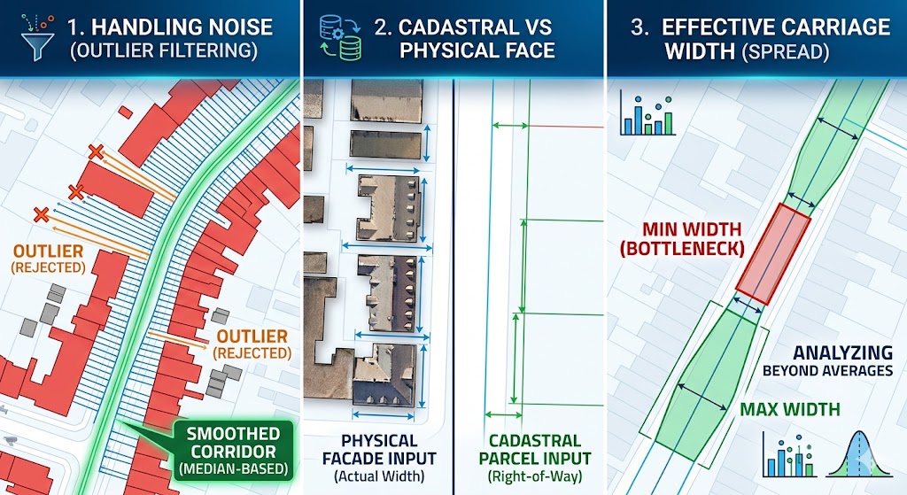
1. Filtering Noise: Parked Cars & Setback Lines
Urban environments are rarely perfect corridors. Irregular setbacks, recessed facades, or temporary obstructions can skew data. The tool addresses this through a Median-based Outlier Filter:
-
The Logic: It calculates the local median width for each specific street segment.
-
The Action: Every individual measurement ray (transect) is compared against this median.
-
The Result: If a transect hits a deep setback or a protruding element that exceeds a user-defined threshold, it is automatically rejected. This effectively "smooths" the corridor, focusing on the most consistent physical street edge.
2. Cadastral vs. Physical Precision
The tool’s output is only as good as the input, offering flexibility based on your project goals:
-
Physical Facades: Using LiDAR-extracted footprints allows you to measure the actual physical carriage width.
-
Cadastral Data: Using legal parcel boundaries allows you to calculate the legal right-of-way. The tool measures strictly to the geometry provided, letting the user define what "width" means for their specific study.
3. Analyzing the "Spread": Min/Max Metrics
In historic or "old urban fabric," a single "Average" width can be deceptive. A street might be wide on average but have a narrow bottleneck that prevents emergency vehicle access or reduces walkability.
The tool’s output schema includes:
-
Min_Width & Max_Width: To identify critical constrictions.
-
Standard Deviation (Std_Width): To quantify the irregularity of the street corridor.
-
Mean & Median: For general morphological classification.
By analyzing the spread, researchers can diagnose the effective carriage width, identifying exactly where the physical corridor constricts regardless of the statistical average.
Architecture that respects the organic nature of the city is the only way to generate true urban intelligence.
I invite you to use these robust metrics in your next project. Share your thoughts or reach out for custom GIS development!
Download the Street Width Calculator Tool:
Click here
Developer: Mohammadmehdi Zare
Website: www.mohammadmehdizare.com